Make a donation
Gear up for your next adventure:
As an Amazon Associate, this site earns from qualifying purchases at no extra cost to you.
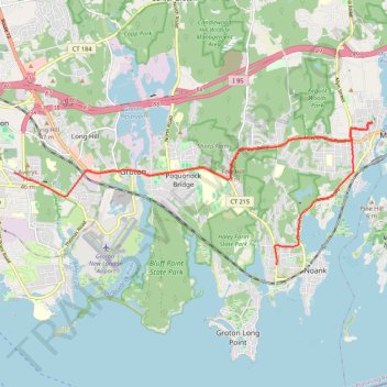
2026-04-14_13-58_Tue
- Distance: 9.4 mi
- Elevation gain: 768 ft
- Maximum elevation: 236 ft
- Elevation loss: 810 ft
- Minimum elevation: 10 ft
- Moving time: 21 m 46 s
- Moving speed: 25.8 mph
- Maximum speed: 46.2 mph
- Total time: 23 m 16 s
- Global speed: 24.1 mph
Interactive trail map
Make a donation
Gear up for your next adventure:
As an Amazon Associate, this site earns from qualifying purchases at no extra cost to you.
Trail profile
- Distance: 9.4 mi
- Elevation gain: 768 ft
- Maximum elevation: 236 ft
- Elevation loss: 810 ft
- Minimum elevation: 10 ft
- Moving time: 21 m 46 s
- Moving speed: 25.8 mph
- Maximum speed: 46.2 mph
- Total time: 23 m 16 s
- Global speed: 24.1 mph
Make a donation
Gear up for your next adventure:
As an Amazon Associate, this site earns from qualifying purchases at no extra cost to you.
About this trail
Name: 2026-04-14_13-58_Tue trail, distance, elevation, map, profile, GPS track
Coordinates: 41.32692 -72.07213 41.35694 -71.97178
Topography: Southeastern Connecticut Planning Region topographic map, elevation, terrain
Make a donation
Gear up for your next adventure:
As an Amazon Associate, this site earns from qualifying purchases at no extra cost to you.
Other hiking, mountain biking, running and outdoor activity trails
Click on a trail to view its statistics, map and profile.
Bluff Point Loop Trail in Bluff Point State Park
United States > Connecticut > Southeastern Connecticut Planning Region > Groton > Poquonock Bridge
Hiking the Bluff Point Loop offers a delightful blend of coastal scenery and serene woodlands. As you traverse the well-marked paths, you can enjoy stunning views of Long Island Sound, particularly from the bluff where the landscape opens up dramatically. The trail is popular for its diverse wildlife, making…
Distance: 3.6 mi • Elevation gain: 200 ft • Maximum elevation: 125 ft
Bluff Point State Park loop hike
United States > Connecticut > Southeastern Connecticut Planning Region > Groton > Poquonock Bridge
Distance: 1.3 mi • Elevation gain: 128 ft • Maximum elevation: 85 ft