Thank you for supporting this site ❤️
Make a donation
Make a donation
Gear up for your next adventure:
As an Amazon Associate, this site earns from qualifying purchases at no extra cost to you.
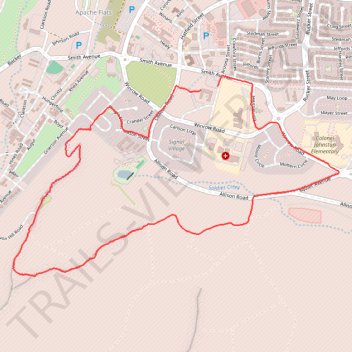
Huachuca Mountains Trail Loop
- Distance: 4.4 mi
- Elevation gain: 728 ft
- Maximum elevation: 5,545 ft
- Elevation loss: 741 ft
- Minimum elevation: 4,852 ft
- Moving time: 57 m 49 s
- Moving speed: 4.6 mph
- Maximum speed: 8.5 mph
- Total time: 59 m
- Global speed: 4.5 mph
Interactive trail map
Thank you for supporting this site ❤️
Make a donation
Make a donation
Gear up for your next adventure:
As an Amazon Associate, this site earns from qualifying purchases at no extra cost to you.
Trail profile
- Distance: 4.4 mi
- Elevation gain: 728 ft
- Maximum elevation: 5,545 ft
- Elevation loss: 741 ft
- Minimum elevation: 4,852 ft
- Moving time: 57 m 49 s
- Moving speed: 4.6 mph
- Maximum speed: 8.5 mph
- Total time: 59 m
- Global speed: 4.5 mph
Thank you for supporting this site ❤️
Make a donation
Make a donation
Gear up for your next adventure:
As an Amazon Associate, this site earns from qualifying purchases at no extra cost to you.
About this trail
Name: Huachuca Mountains Trail Loop trail, distance, elevation, map, profile, GPS track
Coordinates: 31.54080 -110.36876 31.55394 -110.34369
Topography: Sierra Vista topographic map, elevation, terrain
Thank you for supporting this site ❤️
Make a donation
Make a donation
Gear up for your next adventure:
As an Amazon Associate, this site earns from qualifying purchases at no extra cost to you.