Make a donation
Gear up for your next adventure:
As an Amazon Associate, this site earns from qualifying purchases at no extra cost to you.
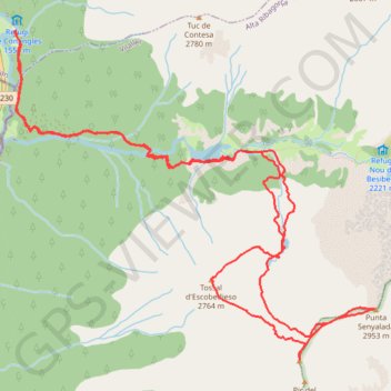
Tossal d'Escobidieso - Pic de Baserca - Punta Senyalada
- Distance: 10.5 mi
- Elevation gain: 5,784 ft
- Maximum elevation: 9,626 ft
- Elevation loss: 5,781 ft
- Minimum elevation: 4,941 ft
- Moving time: 7 h 51 m
- Moving speed: 1.3 mph
- Maximum speed: 4.2 mph
- Total time: 9 h 54 m
- Global speed: 1.1 mph
Interactive trail map
Make a donation
Gear up for your next adventure:
As an Amazon Associate, this site earns from qualifying purchases at no extra cost to you.
Trail profile
- Distance: 10.5 mi
- Elevation gain: 5,784 ft
- Maximum elevation: 9,626 ft
- Elevation loss: 5,781 ft
- Minimum elevation: 4,941 ft
- Moving time: 7 h 51 m
- Moving speed: 1.3 mph
- Maximum speed: 4.2 mph
- Total time: 9 h 54 m
- Global speed: 1.1 mph
Make a donation
Gear up for your next adventure:
As an Amazon Associate, this site earns from qualifying purchases at no extra cost to you.
About this trail
Name: Tossal d'Escobidieso - Pic de Baserca - Punta Senyalada trail, distance, elevation, map, profile, GPS track
Start: N-230, Vielha e Mijaran, Val d'Aran, Lleida, Catalonia, 25530, Spain (42.61442 0.76793)
End: N-230, Vielha e Mijaran, Val d'Aran, Lleida, Catalonia, 25530, Spain (42.61440 0.76809)
Coordinates: 42.58711 0.76792 42.61442 0.80848
Make a donation
Gear up for your next adventure:
As an Amazon Associate, this site earns from qualifying purchases at no extra cost to you.
Other hiking, mountain biking, running and outdoor activity trails
Click on a trail to view its statistics, map and profile.
GR 10 - Traversée des Pyrénées
France > Occitania > Pyrénées-Orientales > Banyuls-sur-Mer
Distance: 543.6 mi • Elevation gain: 187,008 ft • Maximum elevation: 8,527 ft
Southern section — European Divide Trail
France > Auvergne-Rhône-Alpes > Drôme > Valence
Distance: 1,506.1 mi • Elevation gain: 139,026 ft • Maximum elevation: 6,578 ft
1 LUCENA - MONTPELLIER
Distance: 1,842.0 mi • Elevation gain: 96,785 ft • Maximum elevation: 3,438 ft