Thank you for supporting this site ❤️
Make a donation
Make a donation
Gear up for your next adventure:
As an Amazon Associate, this site earns from qualifying purchases at no extra cost to you.
Grays Peak
Interactive trail map
Thank you for supporting this site ❤️
Make a donation
Make a donation
Gear up for your next adventure:
As an Amazon Associate, this site earns from qualifying purchases at no extra cost to you.
Trail profile
- Distance: 3.5 mi
- Elevation gain: 1,224 ft
- Maximum elevation: 7,907 ft
- Elevation loss: 95 ft
- Minimum elevation: 6,772 ft
Thank you for supporting this site ❤️
Make a donation
Make a donation
Gear up for your next adventure:
As an Amazon Associate, this site earns from qualifying purchases at no extra cost to you.
About this trail
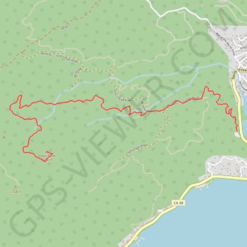
Name: Grays Peak trail, distance, elevation, map, profile, GPS track
End: Gray's Peak Trail, San Bernardino County, California, 92333, United States (34.26109 -116.97118)
Coordinates: 34.26013 -116.97580 34.26771 -116.94787
Topography: San Bernardino County topographic map, elevation, terrain
Thank you for supporting this site ❤️
Make a donation
Make a donation
Gear up for your next adventure:
As an Amazon Associate, this site earns from qualifying purchases at no extra cost to you.