Thank you for supporting this site ❤️
Make a donation
Make a donation
Gear up for your next adventure:
As an Amazon Associate, this site earns from qualifying purchases at no extra cost to you.
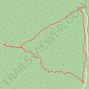
CC Spring Loop from Lovell Canyon
- Distance: 4.5 mi
- Elevation gain: 715 ft
- Maximum elevation: 6,188 ft
- Elevation loss: 725 ft
- Minimum elevation: 5,495 ft
- Moving time: 1 h 49 m
- Moving speed: 2.5 mph
- Maximum speed: 3.7 mph
- Total time: 1 h 55 m
- Global speed: 2.4 mph
Interactive trail map
Thank you for supporting this site ❤️
Make a donation
Make a donation
Gear up for your next adventure:
As an Amazon Associate, this site earns from qualifying purchases at no extra cost to you.
Trail profile
- Distance: 4.5 mi
- Elevation gain: 715 ft
- Maximum elevation: 6,188 ft
- Elevation loss: 725 ft
- Minimum elevation: 5,495 ft
- Moving time: 1 h 49 m
- Moving speed: 2.5 mph
- Maximum speed: 3.7 mph
- Total time: 1 h 55 m
- Global speed: 2.4 mph
Thank you for supporting this site ❤️
Make a donation
Make a donation
Gear up for your next adventure:
As an Amazon Associate, this site earns from qualifying purchases at no extra cost to you.
About this trail
Name: CC Spring Loop from Lovell Canyon trail, distance, elevation, map, profile, GPS track
Start: Lovell Canyon Road, Clark County, Nevada, United States (36.15068 -115.57063)
End: Lovell Canyon Road, Clark County, Nevada, United States (36.15023 -115.57102)
Coordinates: 36.13399 -115.59230 36.15068 -115.57037
Topography: Clark County topographic map, elevation, terrain
Thank you for supporting this site ❤️
Make a donation
Make a donation
Gear up for your next adventure:
As an Amazon Associate, this site earns from qualifying purchases at no extra cost to you.