Thank you for supporting this site ❤️
Make a donation
Make a donation
Gear up for your next adventure:
As an Amazon Associate, this site earns from qualifying purchases at no extra cost to you.
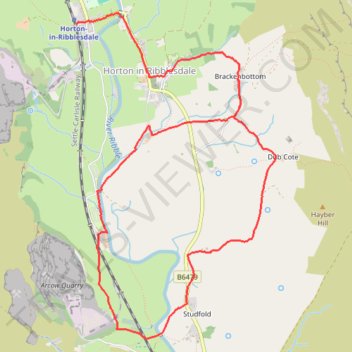
Horton in Ribblesdale loop walk
- Distance: 5.1 mi
- Elevation gain: 433 ft
- Maximum elevation: 942 ft
- Elevation loss: 367 ft
- Minimum elevation: 722 ft
- Moving time: 2 h 16 m
- Moving speed: 2.2 mph
- Maximum speed: 5.0 mph
- Total time: 2 h 27 m
- Global speed: 2.1 mph
Interactive trail map
Thank you for supporting this site ❤️
Make a donation
Make a donation
Gear up for your next adventure:
As an Amazon Associate, this site earns from qualifying purchases at no extra cost to you.
Trail profile
- Distance: 5.1 mi
- Elevation gain: 433 ft
- Maximum elevation: 942 ft
- Elevation loss: 367 ft
- Minimum elevation: 722 ft
- Moving time: 2 h 16 m
- Moving speed: 2.2 mph
- Maximum speed: 5.0 mph
- Total time: 2 h 27 m
- Global speed: 2.1 mph
Thank you for supporting this site ❤️
Make a donation
Make a donation
Gear up for your next adventure:
As an Amazon Associate, this site earns from qualifying purchases at no extra cost to you.
About this trail
Name: Horton in Ribblesdale loop walk trail, distance, elevation, map, profile, GPS track
Coordinates: 54.12640 -2.30173 54.14966 -2.27747
Thank you for supporting this site ❤️
Make a donation
Make a donation
Gear up for your next adventure:
As an Amazon Associate, this site earns from qualifying purchases at no extra cost to you.
Other hiking, mountain biking, running and outdoor activity trails
Click on a trail to view its statistics, map and profile.
Pen-y-ghent, Foxup Road, Hull Pot and Horton Scar Lane Loop Hike
United Kingdom > England > North Yorkshire > Horton in Ribblesdale
Distance: 9.1 mi • Elevation gain: 1,818 ft • Maximum elevation: 2,277 ft