Winchcombe
Interactive trail map
Trail profile
- Distance: 6.3 mi
- Elevation gain: 640 ft
- Maximum elevation: 741 ft
- Elevation loss: 643 ft
- Minimum elevation: 272 ft
- Moving time: 2 h 11 m
- Moving speed: 2.9 mph
- Maximum speed: 6.8 mph
- Total time: 2 h 42 m
- Global speed: 2.3 mph
About this trail
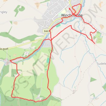
Name: Winchcombe trail, distance, elevation, map, profile, GPS track
Coordinates: 51.93335 -1.98817 51.95546 -1.95652
Other hiking, mountain biking, running and outdoor activity trails
Click on a trail to view its statistics, map and profile.
Winchcombe Cheltenham loop trailrun
United Kingdom > England > Gloucestershire > Winchcombe
Distance: 16.3 mi • Elevation gain: 1,949 ft • Maximum elevation: 1,073 ft
Dean2023-311
United Kingdom > England > Oxfordshire > Oxford
Distance: 192.8 mi • Elevation gain: 11,043 ft • Maximum elevation: 951 ft