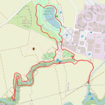
סיור עששיות ליד הפארק האקולוגי בהוד השרון
- Distance: 2.9 mi
- Elevation gain: 52 ft
- Maximum elevation: 72 ft
- Elevation loss: 49 ft
- Minimum elevation: 52 ft
- Moving time: 1 h 11 m
- Moving speed: 2.4 mph
- Maximum speed: 4.7 mph
- Total time: 1 h 18 m
- Global speed: 2.2 mph
Interactive trail map
Trail profile
- Distance: 2.9 mi
- Elevation gain: 52 ft
- Maximum elevation: 72 ft
- Elevation loss: 49 ft
- Minimum elevation: 52 ft
- Moving time: 1 h 11 m
- Moving speed: 2.4 mph
- Maximum speed: 4.7 mph
- Total time: 1 h 18 m
- Global speed: 2.2 mph
About this trail
Name: סיור עששיות ליד הפארק האקולוגי בהוד השרון trail, distance, elevation, map, profile, GPS track
Coordinates: 32.12497 34.88682 32.13384 34.89569