Thank you for supporting this site ❤️
Make a donation
Make a donation
Gear up for your next adventure:
As an Amazon Associate, this site earns from qualifying purchases at no extra cost to you.
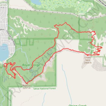
Rowton Peak and Crows Nest Loop from Serene Lakes
- Distance: 8.5 mi
- Elevation gain: 1,614 ft
- Maximum elevation: 7,812 ft
- Elevation loss: 1,617 ft
- Minimum elevation: 6,906 ft
- Moving time: 1 h 45 m
- Moving speed: 4.8 mph
- Maximum speed: 8.8 mph
- Total time: 1 h 59 m
- Global speed: 4.2 mph
Interactive trail map
Thank you for supporting this site ❤️
Make a donation
Make a donation
Gear up for your next adventure:
As an Amazon Associate, this site earns from qualifying purchases at no extra cost to you.
Trail profile
- Distance: 8.5 mi
- Elevation gain: 1,614 ft
- Maximum elevation: 7,812 ft
- Elevation loss: 1,617 ft
- Minimum elevation: 6,906 ft
- Moving time: 1 h 45 m
- Moving speed: 4.8 mph
- Maximum speed: 8.8 mph
- Total time: 1 h 59 m
- Global speed: 4.2 mph
Thank you for supporting this site ❤️
Make a donation
Make a donation
Gear up for your next adventure:
As an Amazon Associate, this site earns from qualifying purchases at no extra cost to you.
About this trail
Name: Rowton Peak and Crows Nest Loop from Serene Lakes trail, distance, elevation, map, profile, GPS track
Start: 879, Soda Springs Road, Placer County, California, 96161, United States (39.29420 -120.38268)
Coordinates: 39.28838 -120.38275 39.30683 -120.34454
Topography: Placer County topographic map, elevation, terrain
Thank you for supporting this site ❤️
Make a donation
Make a donation
Gear up for your next adventure:
As an Amazon Associate, this site earns from qualifying purchases at no extra cost to you.