Tracks_Track2015/09/08_09:05
This is track no: 1
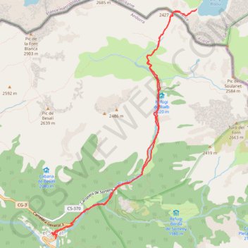
- Distance: 7.7 mi
- Elevation gain: 2,972 ft
- Maximum elevation: 7,864 ft
- Elevation loss: 2,995 ft
- Minimum elevation: 5,121 ft
- Moving time: 4 h 6 m
- Moving speed: 1.9 mph
- Maximum speed: 8.8 mph
- Total time: 4 h 6 m
- Global speed: 1.9 mph
Interactive trail map
Trail profile
- Distance: 7.7 mi
- Elevation gain: 2,972 ft
- Maximum elevation: 7,864 ft
- Elevation loss: 2,995 ft
- Minimum elevation: 5,121 ft
- Moving time: 4 h 6 m
- Moving speed: 1.9 mph
- Maximum speed: 8.8 mph
- Total time: 4 h 6 m
- Global speed: 1.9 mph
About this trail
Name: Tracks_Track2015/09/08_09:05 trail, distance, elevation, map, profile, GPS track
Start: Carretera General 3, El Serrat, Ordino, AD300, Andorra (42.61889 1.53952)
End: Hotel Bringué, Carretera General 3, El Serrat, Ordino, AD300, Andorra (42.61859 1.53944)
Coordinates: 42.61859 1.53854 42.65342 1.56853
Other hiking, mountain biking, running and outdoor activity trails
Click on a trail to view its statistics, map and profile.
GR 10 - Traversée des Pyrénées
France > Occitania > Pyrénées-Orientales > Banyuls-sur-Mer
Distance: 543.6 mi • Elevation gain: 187,008 ft • Maximum elevation: 8,527 ft
1 LUCENA - MONTPELLIER
Distance: 1,842.0 mi • Elevation gain: 96,785 ft • Maximum elevation: 3,438 ft
Southern section — European Divide Trail
France > Auvergne-Rhône-Alpes > Drôme > Valence
Distance: 1,506.1 mi • Elevation gain: 139,026 ft • Maximum elevation: 6,578 ft