Loop hike from Burythorpe
- Distance: 8.1 mi
- Elevation gain: 748 ft
- Maximum elevation: 778 ft
- Elevation loss: 745 ft
- Minimum elevation: 167 ft
- Moving time: 3 h 43 m
- Moving speed: 2.2 mph
- Maximum speed: 3.0 mph
- Total time: 4 h 24 m
- Global speed: 1.8 mph
Interactive trail map
Trail profile
- Distance: 8.1 mi
- Elevation gain: 748 ft
- Maximum elevation: 778 ft
- Elevation loss: 745 ft
- Minimum elevation: 167 ft
- Moving time: 3 h 43 m
- Moving speed: 2.2 mph
- Maximum speed: 3.0 mph
- Total time: 4 h 24 m
- Global speed: 1.8 mph
About this trail
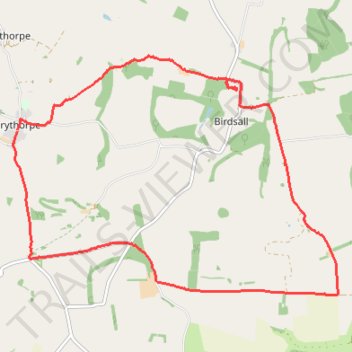
Name: Loop hike from Burythorpe trail, distance, elevation, map, profile, GPS track
Coordinates: 54.05465 -0.79312 54.08145 -0.73095
Other hiking, mountain biking, running and outdoor activity trails
Click on a trail to view its statistics, map and profile.
East Riding of Yorkshire Trail Running
United Kingdom > England > East Riding of Yorkshire
Distance: 20.8 mi • Elevation gain: 1,657 ft • Maximum elevation: 771 ft
Norton-on-Derwent south loop
United Kingdom > England > North Yorkshire > Norton-on-Derwent
Distance: 11.3 mi • Elevation gain: 810 ft • Maximum elevation: 325 ft
Aldro Farm loop
United Kingdom > England > North Yorkshire > Birdsall
Distance: 15.1 mi • Elevation gain: 1,135 ft • Maximum elevation: 778 ft
Derwent loop
United Kingdom > England > North Yorkshire > Norton-on-Derwent
Distance: 12.4 mi • Elevation gain: 751 ft • Maximum elevation: 315 ft
Acklam loop
United Kingdom > England > North Yorkshire > Norton-on-Derwent
Distance: 21.6 mi • Elevation gain: 1,808 ft • Maximum elevation: 778 ft