Make a donation
Gear up for your next adventure:
As an Amazon Associate, this site earns from qualifying purchases at no extra cost to you.
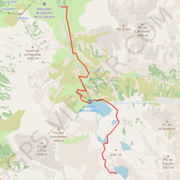
Day 6 Dets Coubous Valley
- Distance: 3.5 mi
- Elevation gain: 2,264 ft
- Maximum elevation: 7,316 ft
- Elevation loss: 20 ft
- Minimum elevation: 5,066 ft
- Moving time: 1 h 12 m
- Moving speed: 2.9 mph
- Maximum speed: 5.2 mph
- Total time: 1 h 12 m
- Global speed: 2.9 mph
Interactive trail map
Make a donation
Gear up for your next adventure:
As an Amazon Associate, this site earns from qualifying purchases at no extra cost to you.
Trail profile
- Distance: 3.5 mi
- Elevation gain: 2,264 ft
- Maximum elevation: 7,316 ft
- Elevation loss: 20 ft
- Minimum elevation: 5,066 ft
- Moving time: 1 h 12 m
- Moving speed: 2.9 mph
- Maximum speed: 5.2 mph
- Total time: 1 h 12 m
- Global speed: 2.9 mph
Make a donation
Gear up for your next adventure:
As an Amazon Associate, this site earns from qualifying purchases at no extra cost to you.
About this trail
Name: Day 6 Dets Coubous Valley trail, distance, elevation, map, profile, GPS track
Coordinates: 42.86347 0.10521 42.89536 0.12040
Make a donation
Gear up for your next adventure:
As an Amazon Associate, this site earns from qualifying purchases at no extra cost to you.
Other hiking, mountain biking, running and outdoor activity trails
Click on a trail to view its statistics, map and profile.
GR 10 - Traversée des Pyrénées
France > Occitania > Pyrénées-Orientales > Banyuls-sur-Mer
Distance: 543.6 mi • Elevation gain: 187,008 ft • Maximum elevation: 8,527 ft
Southern section — European Divide Trail
France > Auvergne-Rhône-Alpes > Drôme > Valence
Distance: 1,506.1 mi • Elevation gain: 139,026 ft • Maximum elevation: 6,578 ft
1 LUCENA - MONTPELLIER
Distance: 1,842.0 mi • Elevation gain: 96,785 ft • Maximum elevation: 3,438 ft