Thank you for supporting this site ❤️
Make a donation
Make a donation
Gear up for your next adventure:
As an Amazon Associate, this site earns from qualifying purchases at no extra cost to you.
Agnes Water - Turkey Beach
Interactive trail map
Thank you for supporting this site ❤️
Make a donation
Make a donation
Gear up for your next adventure:
As an Amazon Associate, this site earns from qualifying purchases at no extra cost to you.
Trail profile
- Distance: 30.4 mi
- Elevation gain: 745 ft
- Maximum elevation: 144 ft
- Elevation loss: 804 ft
- Minimum elevation: 0 ft
Thank you for supporting this site ❤️
Make a donation
Make a donation
Gear up for your next adventure:
As an Amazon Associate, this site earns from qualifying purchases at no extra cost to you.
About this trail
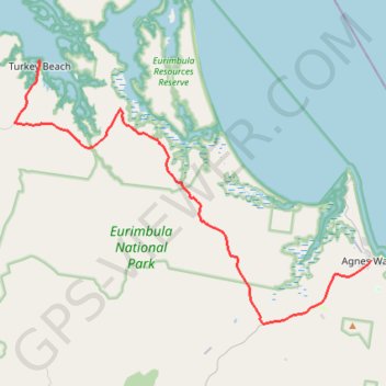
Name: Agnes Water - Turkey Beach trail, distance, elevation, map, profile, GPS track
End: Hancock Street, Turkey Beach, Gladstone Regional, Queensland, Australia (-24.07484 151.65268)
Coordinates: -24.25632 151.63285 -24.07464 151.90331
Thank you for supporting this site ❤️
Make a donation
Make a donation
Gear up for your next adventure:
As an Amazon Associate, this site earns from qualifying purchases at no extra cost to you.