Thank you for supporting this site ❤️
Make a donation
Make a donation
Gear up for your next adventure:
As an Amazon Associate, this site earns from qualifying purchases at no extra cost to you.
Plunkett Conservation Park - Yarrabilba
Interactive trail map
Thank you for supporting this site ❤️
Make a donation
Make a donation
Gear up for your next adventure:
As an Amazon Associate, this site earns from qualifying purchases at no extra cost to you.
Trail profile
- Distance: 10.7 mi
- Elevation gain: 1,355 ft
- Maximum elevation: 518 ft
- Elevation loss: 1,407 ft
- Minimum elevation: 52 ft
Thank you for supporting this site ❤️
Make a donation
Make a donation
Gear up for your next adventure:
As an Amazon Associate, this site earns from qualifying purchases at no extra cost to you.
About this trail
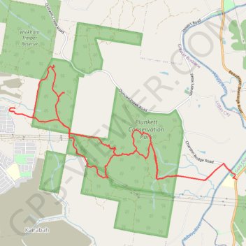
Name: Plunkett Conservation Park - Yarrabilba trail, distance, elevation, map, profile, GPS track
Start: Beaudesert Beenleigh Road, Cedar Creek, Gold Coast City, Queensland, Australia (-27.82741 153.18013)
End: Chardon Bridge Road, Cedar Creek, Gold Coast City, Queensland, Australia (-27.82580 153.17893)
Coordinates: -27.82759 153.13257 -27.80640 153.18013
Thank you for supporting this site ❤️
Make a donation
Make a donation
Gear up for your next adventure:
As an Amazon Associate, this site earns from qualifying purchases at no extra cost to you.