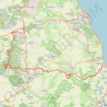
Import a GPX file

גולני ירדנית

  • Distance: 30.0 mi
  • Elevation gain: 3,560 ft
  • Maximum elevation: 1,289 ft
  • Elevation loss: 4,957 ft
  • Minimum elevation: -686 ft

Interactive trail map

Trail profile

  • Distance: 30.0 mi
  • Elevation gain: 3,560 ft
  • Maximum elevation: 1,289 ft
  • Elevation loss: 4,957 ft
  • Minimum elevation: -686 ft

About this trail

Name: גולני ירדנית trail, distance, elevation, map, profile, GPS track

Start: 77, Galil Tachton Regional Council, Kinneret Subdistrict, North District, 1529500, Israel (32.77604 35.40841)

End: Emek HaYarden Regional Council, Kinneret Subdistrict, North District, Israel (32.71147 35.57010)

Coordinates: 32.68527 35.36644 32.77604 35.57010

Gear up for your next adventure:

🩳Quick‑Dry Hiking Shorts - Comfortable and quick‑dry shorts for summer hiking
🧢Outdoor Hiking Hat - Sun protection hat for outdoor explorers
🧣Hiking Neck Gaiter - Multi‑use neck protection for outdoor weather
🎒Outdoor Daypacks - Lightweight backpacks designed for carrying maps and essential gear
🪑Ultralight Camp Chairs - Portable seating for resting after a long day of mapping

As an Amazon Associate, this site earns from qualifying purchases at no extra cost to you.