Crediton Walk
- Distance: 3.1 mi
- Elevation gain: 341 ft
- Maximum elevation: 295 ft
- Elevation loss: 341 ft
- Minimum elevation: 112 ft
- Moving time: 1 h 28 m
- Moving speed: 2.1 mph
- Maximum speed: 4.6 mph
- Total time: 1 h 35 m
- Global speed: 1.9 mph
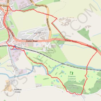
Interactive trail map
Trail profile
- Distance: 3.1 mi
- Elevation gain: 341 ft
- Maximum elevation: 295 ft
- Elevation loss: 341 ft
- Minimum elevation: 112 ft
- Moving time: 1 h 28 m
- Moving speed: 2.1 mph
- Maximum speed: 4.6 mph
- Total time: 1 h 35 m
- Global speed: 1.9 mph
About this trail
Name: Crediton Walk trail, distance, elevation, map, profile, GPS track
Start: Fordton, Crediton, Mid Devon, Devon, England, EX17 3FA, United Kingdom (50.78315 -3.64678)
Coordinates: 50.77661 -3.64914 50.78881 -3.62886
Other hiking, mountain biking, running and outdoor activity trails
Click on a trail to view its statistics, map and profile.
Crediton - Newton St Cyres
United Kingdom > England > Devon > Mid Devon > Crediton
Mid devon ride
Distance: 9.0 mi • Elevation gain: 528 ft • Maximum elevation: 272 ft