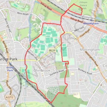
Mottingham, Chinbrook
Morning Walk
- Distance: 4.5 mi
- Elevation gain: 292 ft
- Maximum elevation: 259 ft
- Elevation loss: 292 ft
- Minimum elevation: 105 ft
- Moving time: 1 h 30 m
- Moving speed: 3.0 mph
- Maximum speed: 4.4 mph
- Total time: 1 h 31 m
- Global speed: 3.0 mph
Interactive trail map
Trail profile
- Distance: 4.5 mi
- Elevation gain: 292 ft
- Maximum elevation: 259 ft
- Elevation loss: 292 ft
- Minimum elevation: 105 ft
- Moving time: 1 h 30 m
- Moving speed: 3.0 mph
- Maximum speed: 4.4 mph
- Total time: 1 h 31 m
- Global speed: 3.0 mph
About this trail
Name: Mottingham, Chinbrook trail, distance, elevation, map, profile, GPS track
Coordinates: 51.42239 0.02717 51.44373 0.04695
Other hiking, mountain biking, running and outdoor activity trails
Click on a trail to view its statistics, map and profile.
Eltham Morning Walk
United Kingdom > England > London
Distance: 5.0 mi • Elevation gain: 282 ft • Maximum elevation: 223 ft