Make a donation
Gear up for your next adventure:
As an Amazon Associate, this site earns from qualifying purchases at no extra cost to you.
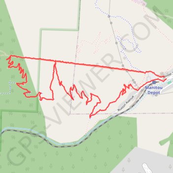
The Manitou Incline loop hike in Pike National Forest
The Incline is a thrilling challenge that gains about 2,000 feet in just a mile. As you ascend, you'll navigate steep steps and rugged terrain, but the panoramic views of Colorado Springs from the top are absolutely breathtaking and make every hard-earned step worth it. The descent via Barr Trail offers a beautiful contrast, with winding paths through lush forests and stunning vistas that provide a perfect cooldown after the climb. #Hiking #Loop #Mountain #Forest #Nature #Pike
- Distance: 4.3 mi
- Elevation gain: 2,047 ft
- Maximum elevation: 8,573 ft
- Elevation loss: 2,044 ft
- Minimum elevation: 6,549 ft
- Moving time: 2 h 10 m
- Moving speed: 2.0 mph
- Maximum speed: 4.0 mph
- Total time: 4 h 43 m
- Global speed: 0.9 mph
Interactive trail map
Make a donation
Gear up for your next adventure:
As an Amazon Associate, this site earns from qualifying purchases at no extra cost to you.
Trail profile
- Distance: 4.3 mi
- Elevation gain: 2,047 ft
- Maximum elevation: 8,573 ft
- Elevation loss: 2,044 ft
- Minimum elevation: 6,549 ft
- Moving time: 2 h 10 m
- Moving speed: 2.0 mph
- Maximum speed: 4.0 mph
- Total time: 4 h 43 m
- Global speed: 0.9 mph
Make a donation
Gear up for your next adventure:
As an Amazon Associate, this site earns from qualifying purchases at no extra cost to you.
About this trail
Name: The Manitou Incline loop hike in Pike National Forest trail, distance, elevation, map, profile, GPS track
End: Ruxton Avenue, Manitou Springs, El Paso County, Colorado, 80829, United States (38.85635 -104.92987)
Coordinates: 38.85292 -104.94801 38.85840 -104.92987
Topography: El Paso County topographic map, elevation, terrain
Make a donation
Gear up for your next adventure:
As an Amazon Associate, this site earns from qualifying purchases at no extra cost to you.
Other hiking, mountain biking, running and outdoor activity trails
Click on a trail to view its statistics, map and profile.