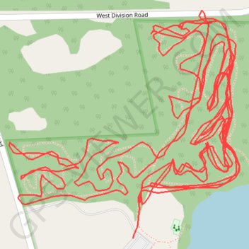
Red Mill County Park MTB Trails
- Distance: 4.3 mi
- Elevation gain: 180 ft
- Maximum elevation: 781 ft
- Elevation loss: 167 ft
- Minimum elevation: 738 ft
Interactive trail map
Trail profile
- Distance: 4.3 mi
- Elevation gain: 180 ft
- Maximum elevation: 781 ft
- Elevation loss: 167 ft
- Minimum elevation: 738 ft
About this trail
Name: Red Mill County Park MTB Trails trail, distance, elevation, map, profile, GPS track
Coordinates: 41.60376 -86.88107 41.60726 -86.87635
Topography: LaPorte County topographic map, elevation, terrain