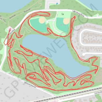
Soldiers Memorial Park MTB Trails
- Distance: 7.0 mi
- Elevation gain: 253 ft
- Maximum elevation: 850 ft
- Elevation loss: 253 ft
- Minimum elevation: 807 ft
Interactive trail map
Trail profile
- Distance: 7.0 mi
- Elevation gain: 253 ft
- Maximum elevation: 850 ft
- Elevation loss: 253 ft
- Minimum elevation: 807 ft
About this trail
Name: Soldiers Memorial Park MTB Trails trail, distance, elevation, map, profile, GPS track
Start: Bluffside, La Porte, LaPorte County, Indiana, 46350, United States (41.60814 -86.75087)
End: Bluffside, La Porte, LaPorte County, Indiana, 46350, United States (41.60818 -86.75090)
Coordinates: 41.60487 -86.75138 41.60907 -86.74469
Topography: LaPorte County topographic map, elevation, terrain
Other hiking, mountain biking, running and outdoor activity trails
Click on a trail to view its statistics, map and profile.
New Bike lanes and construction in La Porte
United States > Indiana > LaPorte County > La Porte
Distance: 18.7 mi • Elevation gain: 469 ft • Maximum elevation: 856 ft