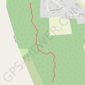
Long Beard Trail
- Distance: 0.8 mi
- Elevation gain: 154 ft
- Maximum elevation: 1,526 ft
- Elevation loss: 56 ft
- Minimum elevation: 1,388 ft
- Moving time: 17 m 22 s
- Moving speed: 2.8 mph
- Maximum speed: 4.6 mph
- Total time: 19 m 24 s
- Global speed: 2.5 mph
Interactive trail map
Trail profile
- Distance: 0.8 mi
- Elevation gain: 154 ft
- Maximum elevation: 1,526 ft
- Elevation loss: 56 ft
- Minimum elevation: 1,388 ft
- Moving time: 17 m 22 s
- Moving speed: 2.8 mph
- Maximum speed: 4.6 mph
- Total time: 19 m 24 s
- Global speed: 2.5 mph
About this trail
Name: Long Beard Trail trail, distance, elevation, map, profile, GPS track
Start: 6A, Oakland Township, Venango County, Pennsylvania, United States (41.49848 -79.76947)
Coordinates: 41.49848 -79.77263 41.50711 -79.76893
Topography: Oakland Township topographic map, elevation, terrain
Other hiking, mountain biking, running and outdoor activity trails
Click on a trail to view its statistics, map and profile.
Long Beard Trail
United States > Pennsylvania > Venango County > Oakland Township > Dempseytown
Distance: 0.6 mi • Elevation gain: 144 ft • Maximum elevation: 1,535 ft