Thank you for supporting this site ❤️
Make a donation
Make a donation
Gear up for your next adventure:
As an Amazon Associate, this site earns from qualifying purchases at no extra cost to you.
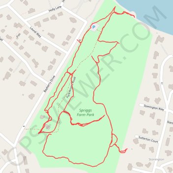
Spriggs Farm Park Loop
- Distance: 2.1 mi
- Elevation gain: 98 ft
- Maximum elevation: 66 ft
- Elevation loss: 98 ft
- Minimum elevation: 7 ft
- Moving time: 56 m 8 s
- Moving speed: 2.3 mph
- Maximum speed: 5.3 mph
- Total time: 1 h 10 m
- Global speed: 1.8 mph
Interactive trail map
Thank you for supporting this site ❤️
Make a donation
Make a donation
Gear up for your next adventure:
As an Amazon Associate, this site earns from qualifying purchases at no extra cost to you.
Trail profile
- Distance: 2.1 mi
- Elevation gain: 98 ft
- Maximum elevation: 66 ft
- Elevation loss: 98 ft
- Minimum elevation: 7 ft
- Moving time: 56 m 8 s
- Moving speed: 2.3 mph
- Maximum speed: 5.3 mph
- Total time: 1 h 10 m
- Global speed: 1.8 mph
Thank you for supporting this site ❤️
Make a donation
Make a donation
Gear up for your next adventure:
As an Amazon Associate, this site earns from qualifying purchases at no extra cost to you.
About this trail
Name: Spriggs Farm Park Loop trail, distance, elevation, map, profile, GPS track
Coordinates: 39.05542 -76.47639 39.06074 -76.47227
Topography: Anne Arundel County topographic map, elevation, terrain
Thank you for supporting this site ❤️
Make a donation
Make a donation
Gear up for your next adventure:
As an Amazon Associate, this site earns from qualifying purchases at no extra cost to you.