Thank you for supporting this site ❤️
Make a donation
Make a donation
Gear up for your next adventure:
As an Amazon Associate, this site earns from qualifying purchases at no extra cost to you.
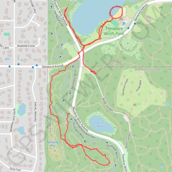
Wirth Lake in Theodore Wirth Park
- Distance: 2.1 mi
- Elevation gain: 138 ft
- Maximum elevation: 942 ft
- Elevation loss: 177 ft
- Minimum elevation: 807 ft
- Moving time: 46 m 26 s
- Moving speed: 2.7 mph
- Maximum speed: 4.7 mph
- Total time: 51 m 18 s
- Global speed: 2.4 mph
Interactive trail map
Thank you for supporting this site ❤️
Make a donation
Make a donation
Gear up for your next adventure:
As an Amazon Associate, this site earns from qualifying purchases at no extra cost to you.
Trail profile
- Distance: 2.1 mi
- Elevation gain: 138 ft
- Maximum elevation: 942 ft
- Elevation loss: 177 ft
- Minimum elevation: 807 ft
- Moving time: 46 m 26 s
- Moving speed: 2.7 mph
- Maximum speed: 4.7 mph
- Total time: 51 m 18 s
- Global speed: 2.4 mph
Thank you for supporting this site ❤️
Make a donation
Make a donation
Gear up for your next adventure:
As an Amazon Associate, this site earns from qualifying purchases at no extra cost to you.
About this trail
Name: Wirth Lake in Theodore Wirth Park trail, distance, elevation, map, profile, GPS track
Coordinates: 44.97179 -93.32858 44.98041 -93.32299
Topography: Minneapolis topographic map, elevation, terrain
Thank you for supporting this site ❤️
Make a donation
Make a donation
Gear up for your next adventure:
As an Amazon Associate, this site earns from qualifying purchases at no extra cost to you.