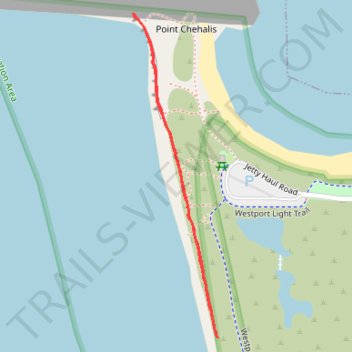
Westport Light State Park - Cliff base
- Distance: 0.8 mi
- Elevation gain: 33 ft
- Maximum elevation: 23 ft
- Elevation loss: 30 ft
- Minimum elevation: 0 ft
- Moving time: 13 m 34 s
- Moving speed: 3.4 mph
- Maximum speed: 6.0 mph
- Total time: 13 m 34 s
- Global speed: 3.4 mph
Interactive trail map
Trail profile
- Distance: 0.8 mi
- Elevation gain: 33 ft
- Maximum elevation: 23 ft
- Elevation loss: 30 ft
- Minimum elevation: 0 ft
- Moving time: 13 m 34 s
- Moving speed: 3.4 mph
- Maximum speed: 6.0 mph
- Total time: 13 m 34 s
- Global speed: 3.4 mph
About this trail
Name: Westport Light State Park - Cliff base trail, distance, elevation, map, profile, GPS track
Coordinates: 46.89970 -124.13289 46.90494 -124.13089
Topography: Grays Harbor County topographic map, elevation, terrain