Thank you for supporting this site ❤️
Make a donation
Make a donation
Gear up for your next adventure:
As an Amazon Associate, this site earns from qualifying purchases at no extra cost to you.
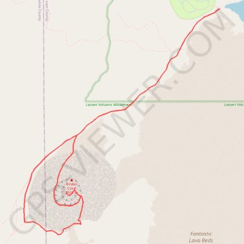
Cinder Cone Trail
- Distance: 4.7 mi
- Elevation gain: 1,070 ft
- Maximum elevation: 6,834 ft
- Elevation loss: 1,070 ft
- Minimum elevation: 6,093 ft
Interactive trail map
Thank you for supporting this site ❤️
Make a donation
Make a donation
Gear up for your next adventure:
As an Amazon Associate, this site earns from qualifying purchases at no extra cost to you.
Trail profile
- Distance: 4.7 mi
- Elevation gain: 1,070 ft
- Maximum elevation: 6,834 ft
- Elevation loss: 1,070 ft
- Minimum elevation: 6,093 ft
Thank you for supporting this site ❤️
Make a donation
Make a donation
Gear up for your next adventure:
As an Amazon Associate, this site earns from qualifying purchases at no extra cost to you.
About this trail
Name: Cinder Cone Trail trail, distance, elevation, map, profile, GPS track
Start: Butte Lake To Snag Lake Trail, Lassen County, California, United States (40.56385 -121.30210)
End: Butte Lake To Snag Lake Trail, Lassen County, California, United States (40.56385 -121.30209)
Coordinates: 40.54358 -121.32527 40.56385 -121.30209
Topography: Lassen County topographic map, elevation, terrain
Thank you for supporting this site ❤️
Make a donation
Make a donation
Gear up for your next adventure:
As an Amazon Associate, this site earns from qualifying purchases at no extra cost to you.