Make a donation
Gear up for your next adventure:
As an Amazon Associate, this site earns from qualifying purchases at no extra cost to you.
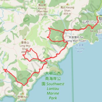
靈浪 靈浪左 狗嶺涌 靈白左右
Islands District Hike
- Distance: 9.6 mi
- Elevation gain: 2,795 ft
- Maximum elevation: 1,033 ft
- Elevation loss: 2,769 ft
- Minimum elevation: 180 ft
- Moving time: 4 h 35 m
- Moving speed: 2.1 mph
- Maximum speed: 14.9 mph
- Total time: 9 h 14 m
- Global speed: 1.0 mph
Interactive trail map
Make a donation
Gear up for your next adventure:
As an Amazon Associate, this site earns from qualifying purchases at no extra cost to you.
Trail profile
- Distance: 9.6 mi
- Elevation gain: 2,795 ft
- Maximum elevation: 1,033 ft
- Elevation loss: 2,769 ft
- Minimum elevation: 180 ft
- Moving time: 4 h 35 m
- Moving speed: 2.1 mph
- Maximum speed: 14.9 mph
- Total time: 9 h 14 m
- Global speed: 1.0 mph
Make a donation
Gear up for your next adventure:
As an Amazon Associate, this site earns from qualifying purchases at no extra cost to you.
About this trail
Name: 靈浪 靈浪左 狗嶺涌 靈白左右 trail, distance, elevation, map, profile, GPS track
End: Wang Pui Road, Shek Pik, Islands District, New Territories, Hong Kong, China (22.22817 113.89095)
Coordinates: 22.20731 113.86069 22.22817 113.89142
Make a donation
Gear up for your next adventure:
As an Amazon Associate, this site earns from qualifying purchases at no extra cost to you.
Other hiking, mountain biking, running and outdoor activity trails
Click on a trail to view its statistics, map and profile.
2024 4TUL Half Loop Final
China > Hong Kong > Tsuen Wan District > Chuen Lung Village > Chuen Lung Cha Tau Wo
Distance: 55.3 mi • Elevation gain: 7,438 ft • Maximum elevation: 1,755 ft
深坑瀝小路
China > Hong Kong > Islands District > Luk Wu
Distance: 10.3 mi • Elevation gain: 2,382 ft • Maximum elevation: 1,516 ft
羗山東坑 大浪坑左源 羗山北坑左源 凌風石澗
China > Hong Kong > Islands District
Islands District Hike
Distance: 5.9 mi • Elevation gain: 2,457 ft • Maximum elevation: 1,430 ft