Thank you for supporting this site ❤️
Make a donation
Make a donation
Gear up for your next adventure:
As an Amazon Associate, this site earns from qualifying purchases at no extra cost to you.
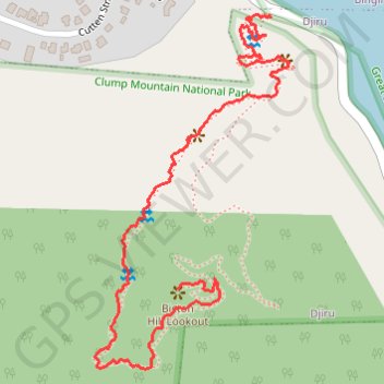
Bicton Hill walking track
Bicton Hill Lookout
- Distance: 1.3 mi
- Elevation gain: 561 ft
- Maximum elevation: 564 ft
- Elevation loss: 69 ft
- Minimum elevation: 62 ft
- Moving time: 35 m 46 s
- Moving speed: 2.2 mph
- Maximum speed: 8.6 mph
- Total time: 1 h 48 m
- Global speed: 0.7 mph
Interactive trail map
Thank you for supporting this site ❤️
Make a donation
Make a donation
Gear up for your next adventure:
As an Amazon Associate, this site earns from qualifying purchases at no extra cost to you.
Trail profile
- Distance: 1.3 mi
- Elevation gain: 561 ft
- Maximum elevation: 564 ft
- Elevation loss: 69 ft
- Minimum elevation: 62 ft
- Moving time: 35 m 46 s
- Moving speed: 2.2 mph
- Maximum speed: 8.6 mph
- Total time: 1 h 48 m
- Global speed: 0.7 mph
Thank you for supporting this site ❤️
Make a donation
Make a donation
Gear up for your next adventure:
As an Amazon Associate, this site earns from qualifying purchases at no extra cost to you.
About this trail
Name: Bicton Hill walking track trail, distance, elevation, map, profile, GPS track
Coordinates: -17.84253 146.09713 -17.83584 146.10097
Thank you for supporting this site ❤️
Make a donation
Make a donation
Gear up for your next adventure:
As an Amazon Associate, this site earns from qualifying purchases at no extra cost to you.