Thank you for supporting this site ❤️
Make a donation
Make a donation
Gear up for your next adventure:
As an Amazon Associate, this site earns from qualifying purchases at no extra cost to you.
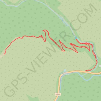
Hiking Jardine
- Distance: 3.6 mi
- Elevation gain: 1,624 ft
- Maximum elevation: 6,969 ft
- Elevation loss: 1,621 ft
- Minimum elevation: 5,535 ft
- Moving time: 1 h 33 m
- Moving speed: 2.3 mph
- Maximum speed: 5.2 mph
- Total time: 1 h 57 m
- Global speed: 1.8 mph
Interactive trail map
Thank you for supporting this site ❤️
Make a donation
Make a donation
Gear up for your next adventure:
As an Amazon Associate, this site earns from qualifying purchases at no extra cost to you.
Trail profile
- Distance: 3.6 mi
- Elevation gain: 1,624 ft
- Maximum elevation: 6,969 ft
- Elevation loss: 1,621 ft
- Minimum elevation: 5,535 ft
- Moving time: 1 h 33 m
- Moving speed: 2.3 mph
- Maximum speed: 5.2 mph
- Total time: 1 h 57 m
- Global speed: 1.8 mph
Thank you for supporting this site ❤️
Make a donation
Make a donation
Gear up for your next adventure:
As an Amazon Associate, this site earns from qualifying purchases at no extra cost to you.
About this trail
Name: Hiking Jardine trail, distance, elevation, map, profile, GPS track
End: US 89, Brachipad Summer Home Area, Cache County, Utah, United States (41.81409 -111.62122)
Coordinates: 41.81407 -111.63256 41.81836 -111.61954
Topography: Cache County topographic map, elevation, terrain
Thank you for supporting this site ❤️
Make a donation
Make a donation
Gear up for your next adventure:
As an Amazon Associate, this site earns from qualifying purchases at no extra cost to you.