Docharn wood track
Docharn track only
- Distance: 3.1 mi
- Elevation gain: 453 ft
- Maximum elevation: 1,112 ft
- Elevation loss: 436 ft
- Minimum elevation: 748 ft
- Moving time: 28 m 50 s
- Moving speed: 6.5 mph
- Maximum speed: 27.6 mph
- Total time: 35 m 30 s
- Global speed: 5.3 mph
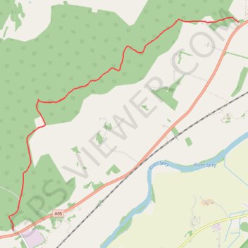
Interactive trail map
Trail profile
- Distance: 3.1 mi
- Elevation gain: 453 ft
- Maximum elevation: 1,112 ft
- Elevation loss: 436 ft
- Minimum elevation: 748 ft
- Moving time: 28 m 50 s
- Moving speed: 6.5 mph
- Maximum speed: 27.6 mph
- Total time: 35 m 30 s
- Global speed: 5.3 mph
About this trail
Name: Docharn wood track trail, distance, elevation, map, profile, GPS track
Start: A95, Chapleton, Dulnain Bridge, Highland, Scotland, PH24 3BX, United Kingdom (57.25829 -3.75493)
End: A95, Chapleton, Dulnain Bridge, Highland, Scotland, PH24 3BX, United Kingdom (57.28139 -3.70868)
Coordinates: 57.25829 -3.75576 57.28193 -3.70868
Other hiking, mountain biking, running and outdoor activity trails
Click on a trail to view its statistics, map and profile.
Tracks in Docharn forest and surrounding
United Kingdom > Scotland > Highland > Grantown-on-Spey
Highlands Gravel/Unpaved Cycling
Distance: 28.2 mi • Elevation gain: 1,877 ft • Maximum elevation: 1,112 ft