Thank you for supporting this site ❤️
Make a donation
Make a donation
Gear up for your next adventure:
As an Amazon Associate, this site earns from qualifying purchases at no extra cost to you.
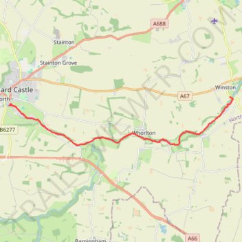
River Tees Kayak
- Distance: 7.6 mi
- Elevation gain: 535 ft
- Maximum elevation: 453 ft
- Elevation loss: 679 ft
- Minimum elevation: 256 ft
- Moving time: 2 h 51 m
- Moving speed: 2.7 mph
- Maximum speed: 5.8 mph
- Total time: 5 h 11 m
- Global speed: 1.5 mph
Interactive trail map
Thank you for supporting this site ❤️
Make a donation
Make a donation
Gear up for your next adventure:
As an Amazon Associate, this site earns from qualifying purchases at no extra cost to you.
Trail profile
- Distance: 7.6 mi
- Elevation gain: 535 ft
- Maximum elevation: 453 ft
- Elevation loss: 679 ft
- Minimum elevation: 256 ft
- Moving time: 2 h 51 m
- Moving speed: 2.7 mph
- Maximum speed: 5.8 mph
- Total time: 5 h 11 m
- Global speed: 1.5 mph
Thank you for supporting this site ❤️
Make a donation
Make a donation
Gear up for your next adventure:
As an Amazon Associate, this site earns from qualifying purchases at no extra cost to you.
About this trail
Name: River Tees Kayak trail, distance, elevation, map, profile, GPS track
End: B6274, Winston, County Durham, North East, England, DL2 3RP, United Kingdom (54.54202 -1.78230)
Coordinates: 54.52404 -1.92469 54.54202 -1.78040
Thank you for supporting this site ❤️
Make a donation
Make a donation
Gear up for your next adventure:
As an Amazon Associate, this site earns from qualifying purchases at no extra cost to you.