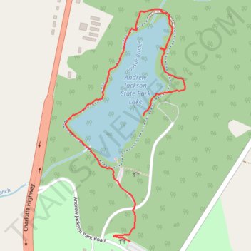
Andrew Jackson State Park and Lake
- Distance: 1.2 mi
- Elevation gain: 72 ft
- Maximum elevation: 581 ft
- Elevation loss: 39 ft
- Minimum elevation: 525 ft
- Moving time: 34 m 52 s
- Moving speed: 2.0 mph
- Maximum speed: 5.5 mph
- Total time: 44 m 12 s
- Global speed: 1.6 mph
Interactive trail map
Trail profile
- Distance: 1.2 mi
- Elevation gain: 72 ft
- Maximum elevation: 581 ft
- Elevation loss: 39 ft
- Minimum elevation: 525 ft
- Moving time: 34 m 52 s
- Moving speed: 2.0 mph
- Maximum speed: 5.5 mph
- Total time: 44 m 12 s
- Global speed: 1.6 mph
About this trail
Name: Andrew Jackson State Park and Lake trail, distance, elevation, map, profile, GPS track
Start: Old Church Road, Lancaster County, South Carolina, 29720, United States (34.84515 -80.80614)
Coordinates: 34.84116 -80.80917 34.84855 -80.80452
Topography: Lancaster County topographic map, elevation, terrain