Make a donation
Gear up for your next adventure:
As an Amazon Associate, this site earns from qualifying purchases at no extra cost to you.
Mountains-to-Sea Trail
Purlear Trail Run
- Distance: 12.2 mi
- Elevation gain: 1,663 ft
- Maximum elevation: 3,990 ft
- Elevation loss: 1,913 ft
- Minimum elevation: 3,209 ft
- Moving time: 2 h 53 m
- Moving speed: 4.2 mph
- Maximum speed: 7.3 mph
- Total time: 2 h 53 m
- Global speed: 4.2 mph
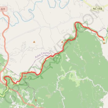
Interactive trail map
Make a donation
Gear up for your next adventure:
As an Amazon Associate, this site earns from qualifying purchases at no extra cost to you.
Trail profile
- Distance: 12.2 mi
- Elevation gain: 1,663 ft
- Maximum elevation: 3,990 ft
- Elevation loss: 1,913 ft
- Minimum elevation: 3,209 ft
- Moving time: 2 h 53 m
- Moving speed: 4.2 mph
- Maximum speed: 7.3 mph
- Total time: 2 h 53 m
- Global speed: 4.2 mph
Make a donation
Gear up for your next adventure:
As an Amazon Associate, this site earns from qualifying purchases at no extra cost to you.
About this trail
Name: Mountains-to-Sea Trail trail, distance, elevation, map, profile, GPS track
Start: Blue Ridge Parkway, Wilkes County, North Carolina, United States (36.27648 -81.37971)
End: Blue Ridge Parkway, Watauga County, North Carolina, 28618, United States (36.23097 -81.50012)
Coordinates: 36.23097 -81.50393 36.29480 -81.37940
Topography: Wilkes County topographic map, elevation, terrain
Make a donation
Gear up for your next adventure:
As an Amazon Associate, this site earns from qualifying purchases at no extra cost to you.