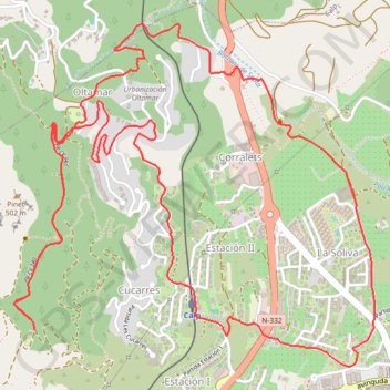
Trail Planner Map
- Distance: 6.6 mi
- Elevation gain: 1,598 ft
- Maximum elevation: 1,115 ft
- Elevation loss: 1,598 ft
- Minimum elevation: 98 ft
Interactive trail map
Trail profile
- Distance: 6.6 mi
- Elevation gain: 1,598 ft
- Maximum elevation: 1,115 ft
- Elevation loss: 1,598 ft
- Minimum elevation: 98 ft
About this trail
Name: Trail Planner Map trail, distance, elevation, map, profile, GPS track
Coordinates: 38.64704 0.02237 38.66299 0.04380
Other hiking, mountain biking, running and outdoor activity trails
Click on a trail to view its statistics, map and profile.
1 LUCENA - MONTPELLIER
Distance: 1,842.0 mi • Elevation gain: 96,785 ft • Maximum elevation: 3,438 ft
Southern section — European Divide Trail
France > Auvergne-Rhône-Alpes > Drôme > Valence
Distance: 1,506.1 mi • Elevation gain: 139,026 ft • Maximum elevation: 6,578 ft