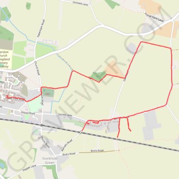
Thank you for supporting this site ❤️
Make a donation
Make a donation
Gear up for your next adventure:
As an Amazon Associate, this site earns from qualifying purchases at no extra cost to you.
Barrel road
- Distance: 2.8 mi
- Elevation gain: 79 ft
- Maximum elevation: 194 ft
- Elevation loss: 79 ft
- Minimum elevation: 131 ft
- Moving time: 49 m 51 s
- Moving speed: 3.4 mph
- Maximum speed: 5.7 mph
- Total time: 1 h 26 m
- Global speed: 1.9 mph
Interactive trail map
Thank you for supporting this site ❤️
Make a donation
Make a donation
Gear up for your next adventure:
As an Amazon Associate, this site earns from qualifying purchases at no extra cost to you.
Trail profile
- Distance: 2.8 mi
- Elevation gain: 79 ft
- Maximum elevation: 194 ft
- Elevation loss: 79 ft
- Minimum elevation: 131 ft
- Moving time: 49 m 51 s
- Moving speed: 3.4 mph
- Maximum speed: 5.7 mph
- Total time: 1 h 26 m
- Global speed: 1.9 mph
Thank you for supporting this site ❤️
Make a donation
Make a donation
Gear up for your next adventure:
As an Amazon Associate, this site earns from qualifying purchases at no extra cost to you.
About this trail
Name: Barrel road trail, distance, elevation, map, profile, GPS track
Coordinates: 52.24791 0.81900 52.25622 0.84246
Thank you for supporting this site ❤️
Make a donation
Make a donation
Gear up for your next adventure:
As an Amazon Associate, this site earns from qualifying purchases at no extra cost to you.