Make a donation
Gear up for your next adventure:
As an Amazon Associate, this site earns from qualifying purchases at no extra cost to you.
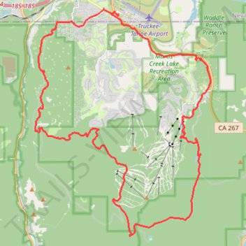
Northstar bike path
- Distance: 26.8 mi
- Elevation gain: 2,907 ft
- Maximum elevation: 7,874 ft
- Elevation loss: 2,907 ft
- Minimum elevation: 5,820 ft
- Moving time: 2 h 45 m
- Moving speed: 9.7 mph
- Maximum speed: 35.6 mph
- Total time: 3 h 17 m
- Global speed: 8.1 mph
Interactive trail map
Make a donation
Gear up for your next adventure:
As an Amazon Associate, this site earns from qualifying purchases at no extra cost to you.
Trail profile
- Distance: 26.8 mi
- Elevation gain: 2,907 ft
- Maximum elevation: 7,874 ft
- Elevation loss: 2,907 ft
- Minimum elevation: 5,820 ft
- Moving time: 2 h 45 m
- Moving speed: 9.7 mph
- Maximum speed: 35.6 mph
- Total time: 3 h 17 m
- Global speed: 8.1 mph
Make a donation
Gear up for your next adventure:
As an Amazon Associate, this site earns from qualifying purchases at no extra cost to you.
About this trail
Name: Northstar bike path trail, distance, elevation, map, profile, GPS track
Start: Soaring Way, Truckee, Nevada County, California, 96161, United States (39.31912 -120.15460)
End: Soaring Way, Truckee, Nevada County, California, 96161, United States (39.31905 -120.15456)
Coordinates: 39.22496 -120.20051 39.32148 -120.10413
Topography: Nevada County topographic map, elevation, terrain
Make a donation
Gear up for your next adventure:
As an Amazon Associate, this site earns from qualifying purchases at no extra cost to you.
Other hiking, mountain biking, running and outdoor activity trails
Click on a trail to view its statistics, map and profile.
Northstar California Loop Run
United States > California > Placer County
Distance: 9.8 mi • Elevation gain: 2,146 ft • Maximum elevation: 7,874 ft
Sawtooth Ridge, Watson Lake and Lookout Mountain Loop Hike
United States > California > Placer County
Distance: 17.8 mi • Elevation gain: 3,153 ft • Maximum elevation: 8,035 ft