Thank you for supporting this site ❤️
Make a donation
Make a donation
Gear up for your next adventure:
As an Amazon Associate, this site earns from qualifying purchases at no extra cost to you.
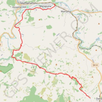
Taumarunui - Owhango
Interactive trail map
Thank you for supporting this site ❤️
Make a donation
Make a donation
Gear up for your next adventure:
As an Amazon Associate, this site earns from qualifying purchases at no extra cost to you.
Trail profile
- Distance: 17.4 mi
- Elevation gain: 2,418 ft
- Maximum elevation: 1,601 ft
- Elevation loss: 1,555 ft
- Minimum elevation: 512 ft
Thank you for supporting this site ❤️
Make a donation
Make a donation
Gear up for your next adventure:
As an Amazon Associate, this site earns from qualifying purchases at no extra cost to you.
About this trail
Name: Taumarunui - Owhango trail, distance, elevation, map, profile, GPS track
End: Hikumutu Road, Ōwhango, Ruapehu District, Manawatū-Whanganui, New Zealand (-38.99575 175.36305)
Coordinates: -38.99575 175.24188 -38.88264 175.36305
Thank you for supporting this site ❤️
Make a donation
Make a donation
Gear up for your next adventure:
As an Amazon Associate, this site earns from qualifying purchases at no extra cost to you.
Other hiking, mountain biking, running and outdoor activity trails
Click on a trail to view its statistics, map and profile.