Import a GPX file

JDRF Murray River Raid

#Bike #Loop

  • Distance: 71.4 mi
  • Elevation gain: 2,917 ft
  • Maximum elevation: 322 ft
  • Elevation loss: 2,917 ft
  • Minimum elevation: 7 ft

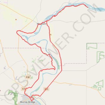
Interactive trail map

Trail profile

  • Distance: 71.4 mi
  • Elevation gain: 2,917 ft
  • Maximum elevation: 322 ft
  • Elevation loss: 2,917 ft
  • Minimum elevation: 7 ft

About this trail

Other hiking, mountain biking, running and outdoor activity trails

Click on a trail to view its statistics, map and profile.

Kinchina Conservation Park

Australia > South Australia > The Rural City of Murray Bridge

#MTB #Loop #Kinchina

Distance: 8.4 mi • Elevation gain: 817 ft • Maximum elevation: 469 ft

Gear up for your next adventure:

🔥Plasma Lighters - Windproof lighters that work in any weather condition
🧢Outdoor Hiking Hat - Sun protection hat for outdoor explorers
🛰️Satellite Messengers - Emergency SOS and two-way messaging for off-grid adventures
🧤Tactile Hiking Gloves - Keep hands warm while operating GPS and smartphone screens
💧Water Filtration Bottles - Safely drink from streams and lakes while exploring

As an Amazon Associate, this site earns from qualifying purchases at no extra cost to you.