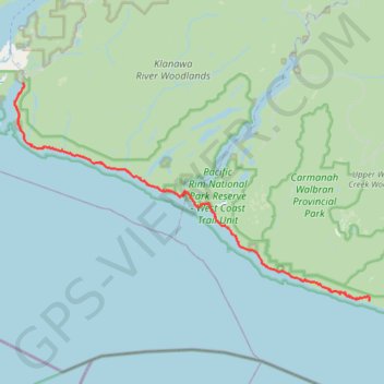
West Coast Trail (Vancouver Island)
Hike along the West Coast Trail via Camper Bay, Cullite Cove, Logan Creek Bridge, Wallbran Creek Camp, Bonilla Creek, Carmanah Creek Camp, Cribs Creek Camp, Dare Point, Nitinat River, Tsuquadra Point Camp, Tsusiat Falls, Klanawa River, Tsocowis Creek Camp, Darling River Camp, Michigan Creek Camp, Pachena Point Lighthouse and Pachena Beach in the Pacific Rim National Park Reserve of Canada on the Vancouver Island. #Hiking #Coast #Sea #Pacific #Ocean #Nature #Forest #Beach #River #Island #WCT #Park
- Distance: 42.6 mi
- Elevation gain: 6,010 ft
- Maximum elevation: 404 ft
- Elevation loss: 6,086 ft
- Minimum elevation: 0 ft
- Moving time: 1 d 2 h
- Moving speed: 1.6 mph
- Maximum speed: 7.2 mph
- Total time: 6 d 23 h
- Global speed: 0.3 mph
Interactive trail map
Trail profile
- Distance: 42.6 mi
- Elevation gain: 6,010 ft
- Maximum elevation: 404 ft
- Elevation loss: 6,086 ft
- Minimum elevation: 0 ft
- Moving time: 1 d 2 h
- Moving speed: 1.6 mph
- Maximum speed: 7.2 mph
- Total time: 6 d 23 h
- Global speed: 0.3 mph
About this trail
Name: West Coast Trail (Vancouver Island) trail, distance, elevation, map, profile, GPS track
Coordinates: 48.55803 -125.13033 48.79314 -124.54968