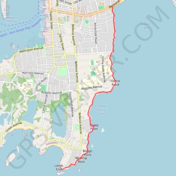
Cliff Walk at Newport, Rhode Island
Hike from Memorial Boulevard to Lands End along Atlantic Coast via Marys Seat, Easton Bay, Breakers Observation Area, Gazebo at Anglesea, Belmont Beach, Sheep Point Cove, Sheep Point, Rough Point and Midship Rock. #Hiking #Walking #Nature #Coast #Sea #Atlantic #Ocean
- Distance: 3.1 mi
- Elevation gain: 151 ft
- Maximum elevation: 30 ft
- Elevation loss: 161 ft
- Minimum elevation: -3 ft
- Moving time: 1 h 27 m
- Moving speed: 2.1 mph
- Maximum speed: 3.2 mph
- Total time: 1 h 42 m
- Global speed: 1.8 mph
Interactive trail map
Trail profile
- Distance: 3.1 mi
- Elevation gain: 151 ft
- Maximum elevation: 30 ft
- Elevation loss: 161 ft
- Minimum elevation: -3 ft
- Moving time: 1 h 27 m
- Moving speed: 2.1 mph
- Maximum speed: 3.2 mph
- Total time: 1 h 42 m
- Global speed: 1.8 mph
About this trail
Name: Cliff Walk at Newport, Rhode Island trail, distance, elevation, map, profile, GPS track
End: Cliff Walk, Newport, Newport County, Rhode Island, 02840, United States (41.45172 -71.31205)
Coordinates: 41.45124 -71.31205 41.48520 -71.29657
Topography: Newport topographic map, elevation, terrain
Other hiking, mountain biking, running and outdoor activity trails
Click on a trail to view its statistics, map and profile.
Cliff Walk in Newport
United States > Rhode Island > Newport County > Newport
The Cliff Walk offers a captivating experience that beautifully combines rugged coastal views with the architectural splendor of historic mansions. As you traverse the path, you'll enjoy stunning panoramas of the Atlantic Ocean on one side while passing by iconic landmarks like The Breakers and Marble House on…
Distance: 7.6 mi • Elevation gain: 305 ft • Maximum elevation: 52 ft