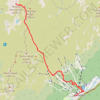
Mount Kosciuszko
- Distance: 12.4 mi
- Elevation gain: 3,022 ft
- Maximum elevation: 7,303 ft
- Elevation loss: 3,018 ft
- Minimum elevation: 4,469 ft
- Moving time: 3 h 31 m
- Moving speed: 3.5 mph
- Maximum speed: 8.2 mph
- Total time: 3 h 59 m
- Global speed: 3.1 mph
Interactive trail map
Trail profile
- Distance: 12.4 mi
- Elevation gain: 3,022 ft
- Maximum elevation: 7,303 ft
- Elevation loss: 3,018 ft
- Minimum elevation: 4,469 ft
- Moving time: 3 h 31 m
- Moving speed: 3.5 mph
- Maximum speed: 8.2 mph
- Total time: 3 h 59 m
- Global speed: 3.1 mph
About this trail
Name: Mount Kosciuszko trail, distance, elevation, map, profile, GPS track
Coordinates: -36.50538 148.26347 -36.45583 148.30867
Other hiking, mountain biking, running and outdoor activity trails
Click on a trail to view its statistics, map and profile.
Mount Kosciuszko Loop
Australia > New South Wales > Charlotte Pass
Kosciuszko National Park. #Hiking #Loop #Kosciuszko
Distance: 28.3 mi • Elevation gain: 6,752 ft • Maximum elevation: 7,303 ft
Cloudride24.FINAL
Distance: 639.3 mi • Elevation gain: 69,823 ft • Maximum elevation: 5,755 ft