Thank you for supporting this site ❤️
Make a donation
Make a donation
Gear up for your next adventure:
As an Amazon Associate, this site earns from qualifying purchases at no extra cost to you.
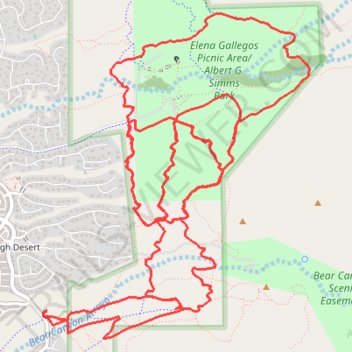
Elena Gallegos / Albert G. Simms Park trails
- Distance: 13.8 mi
- Elevation gain: 1,325 ft
- Maximum elevation: 6,739 ft
- Elevation loss: 1,325 ft
- Minimum elevation: 6,194 ft
- Moving time: 2 h 9 m
- Moving speed: 6.4 mph
- Maximum speed: 19.6 mph
- Total time: 2 h 25 m
- Global speed: 5.7 mph
Interactive trail map
Thank you for supporting this site ❤️
Make a donation
Make a donation
Gear up for your next adventure:
As an Amazon Associate, this site earns from qualifying purchases at no extra cost to you.
Trail profile
- Distance: 13.8 mi
- Elevation gain: 1,325 ft
- Maximum elevation: 6,739 ft
- Elevation loss: 1,325 ft
- Minimum elevation: 6,194 ft
- Moving time: 2 h 9 m
- Moving speed: 6.4 mph
- Maximum speed: 19.6 mph
- Total time: 2 h 25 m
- Global speed: 5.7 mph
Thank you for supporting this site ❤️
Make a donation
Make a donation
Gear up for your next adventure:
As an Amazon Associate, this site earns from qualifying purchases at no extra cost to you.
About this trail
Name: Elena Gallegos / Albert G. Simms Park trails trail, distance, elevation, map, profile, GPS track
Coordinates: 35.14412 -106.48286 35.17023 -106.45669
Topography: Bernalillo County topographic map, elevation, terrain
Thank you for supporting this site ❤️
Make a donation
Make a donation
Gear up for your next adventure:
As an Amazon Associate, this site earns from qualifying purchases at no extra cost to you.