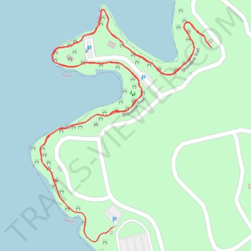
Cedar Hill State Park - Shoreline trail
- Distance: 1.9 mi
- Elevation gain: 66 ft
- Maximum elevation: 548 ft
- Elevation loss: 66 ft
- Minimum elevation: 518 ft
- Moving time: 37 m 16 s
- Moving speed: 3.1 mph
- Maximum speed: 4.0 mph
- Total time: 37 m 16 s
- Global speed: 3.1 mph
Interactive trail map
Trail profile
- Distance: 1.9 mi
- Elevation gain: 66 ft
- Maximum elevation: 548 ft
- Elevation loss: 66 ft
- Minimum elevation: 518 ft
- Moving time: 37 m 16 s
- Moving speed: 3.1 mph
- Maximum speed: 4.0 mph
- Total time: 37 m 16 s
- Global speed: 3.1 mph
About this trail
Name: Cedar Hill State Park - Shoreline trail trail, distance, elevation, map, profile, GPS track
Start: Shoreline Trail, Cedar Hill, Dallas County, Texas, 75249, United States (32.62922 -96.98398)
End: Shoreline Trail, Cedar Hill, Dallas County, Texas, 75249, United States (32.62818 -96.98243)
Coordinates: 32.62784 -96.98443 32.63316 -96.97978
Topography: Dallas County topographic map, elevation, terrain