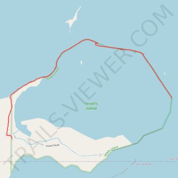
Terrell's Island trail
- Distance: 2.2 mi
- Elevation gain: 33 ft
- Maximum elevation: 768 ft
- Elevation loss: 20 ft
- Minimum elevation: 738 ft
- Moving time: 45 m 31 s
- Moving speed: 2.9 mph
- Maximum speed: 8.5 mph
- Total time: 48 m 18 s
- Global speed: 2.7 mph
Interactive trail map
Trail profile
- Distance: 2.2 mi
- Elevation gain: 33 ft
- Maximum elevation: 768 ft
- Elevation loss: 20 ft
- Minimum elevation: 738 ft
- Moving time: 45 m 31 s
- Moving speed: 2.9 mph
- Maximum speed: 8.5 mph
- Total time: 48 m 18 s
- Global speed: 2.7 mph
About this trail
Name: Terrell's Island trail trail, distance, elevation, map, profile, GPS track
Coordinates: 44.07217 -88.67893 44.08392 -88.65180
Topography: Town of Winneconne topographic map, elevation, terrain