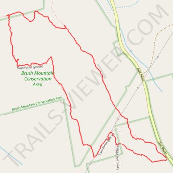
Town Forest Loop in Brush Mountain Conservation Area
- Distance: 2.2 mi
- Elevation gain: 295 ft
- Maximum elevation: 1,329 ft
- Elevation loss: 295 ft
- Minimum elevation: 1,063 ft
- Moving time: 1 h 12 m
- Moving speed: 1.8 mph
- Maximum speed: 10.2 mph
- Total time: 1 h 42 m
- Global speed: 1.3 mph
Interactive trail map
Trail profile
- Distance: 2.2 mi
- Elevation gain: 295 ft
- Maximum elevation: 1,329 ft
- Elevation loss: 295 ft
- Minimum elevation: 1,063 ft
- Moving time: 1 h 12 m
- Moving speed: 1.8 mph
- Maximum speed: 10.2 mph
- Total time: 1 h 42 m
- Global speed: 1.3 mph
About this trail
Name: Town Forest Loop in Brush Mountain Conservation Area trail, distance, elevation, map, profile, GPS track
Coordinates: 42.65939 -72.43014 42.66702 -72.41912
Topography: Franklin County topographic map, elevation, terrain