Make a donation
Gear up for your next adventure:
As an Amazon Associate, this site earns from qualifying purchases at no extra cost to you.
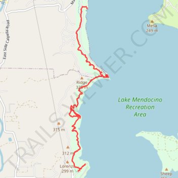
Shakota Trail
Most of the trail from south to north, went off track a bit, nice trail.
- Distance: 3.8 mi
- Elevation gain: 568 ft
- Maximum elevation: 879 ft
- Elevation loss: 692 ft
- Minimum elevation: 751 ft
- Moving time: 1 h 45 m
- Moving speed: 2.1 mph
- Maximum speed: 5.3 mph
- Total time: 2 h 27 m
- Global speed: 1.5 mph
Interactive trail map
Make a donation
Gear up for your next adventure:
As an Amazon Associate, this site earns from qualifying purchases at no extra cost to you.
Trail profile
- Distance: 3.8 mi
- Elevation gain: 568 ft
- Maximum elevation: 879 ft
- Elevation loss: 692 ft
- Minimum elevation: 751 ft
- Moving time: 1 h 45 m
- Moving speed: 2.1 mph
- Maximum speed: 5.3 mph
- Total time: 2 h 27 m
- Global speed: 1.5 mph
Make a donation
Gear up for your next adventure:
As an Amazon Associate, this site earns from qualifying purchases at no extra cost to you.
About this trail
Name: Shakota Trail trail, distance, elevation, map, profile, GPS track
Start: Shakota Trail, Calpella, Mendocino County, California, 95418, United States (39.20557 -123.18449)
End: Shakota Trail, Calpella, Mendocino County, California, 95418, United States (39.23180 -123.18266)
Coordinates: 39.20557 -123.18637 39.23217 -123.17810
Topography: Mendocino County topographic map, elevation, terrain
Make a donation
Gear up for your next adventure:
As an Amazon Associate, this site earns from qualifying purchases at no extra cost to you.