Thank you for supporting this site ❤️
Make a donation
Make a donation
Gear up for your next adventure:
As an Amazon Associate, this site earns from qualifying purchases at no extra cost to you.
Yancey Park
- Distance: 0.2 mi
- Elevation gain: 10 ft
- Maximum elevation: 928 ft
- Elevation loss: 7 ft
- Minimum elevation: 919 ft
- Moving time: 4 m 37 s
- Moving speed: 3.2 mph
- Maximum speed: 4.3 mph
- Total time: 4 m 37 s
- Global speed: 3.2 mph
Interactive trail map
Thank you for supporting this site ❤️
Make a donation
Make a donation
Gear up for your next adventure:
As an Amazon Associate, this site earns from qualifying purchases at no extra cost to you.
Trail profile
- Distance: 0.2 mi
- Elevation gain: 10 ft
- Maximum elevation: 928 ft
- Elevation loss: 7 ft
- Minimum elevation: 919 ft
- Moving time: 4 m 37 s
- Moving speed: 3.2 mph
- Maximum speed: 4.3 mph
- Total time: 4 m 37 s
- Global speed: 3.2 mph
Thank you for supporting this site ❤️
Make a donation
Make a donation
Gear up for your next adventure:
As an Amazon Associate, this site earns from qualifying purchases at no extra cost to you.
About this trail
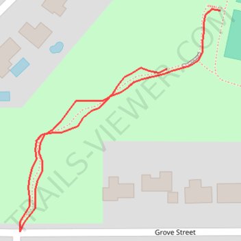
Name: Yancey Park trail, distance, elevation, map, profile, GPS track
Start: Grove Street, Edina, Hennepin County, Minnesota, 55436, United States (44.90015 -93.36303)
End: Grove Street, Edina, Hennepin County, Minnesota, 55436, United States (44.89980 -93.36348)
Coordinates: 44.89883 -93.36472 44.90016 -93.36303
Topography: Hennepin County topographic map, elevation, terrain
Thank you for supporting this site ❤️
Make a donation
Make a donation
Gear up for your next adventure:
As an Amazon Associate, this site earns from qualifying purchases at no extra cost to you.