Thank you for supporting this site ❤️
Make a donation
Make a donation
Gear up for your next adventure:
As an Amazon Associate, this site earns from qualifying purchases at no extra cost to you.
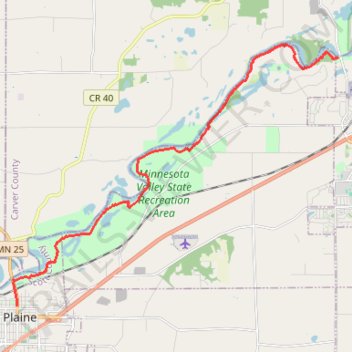
Minnesota river valley state trail, Belle Plaine to Jordan
- Distance: 10.1 mi
- Elevation gain: 348 ft
- Maximum elevation: 846 ft
- Elevation loss: 472 ft
- Minimum elevation: 702 ft
- Moving time: 1 h 53 m
- Moving speed: 5.4 mph
- Maximum speed: 18.1 mph
- Total time: 2 h 1 m
- Global speed: 5.0 mph
Interactive trail map
Thank you for supporting this site ❤️
Make a donation
Make a donation
Gear up for your next adventure:
As an Amazon Associate, this site earns from qualifying purchases at no extra cost to you.
Trail profile
- Distance: 10.1 mi
- Elevation gain: 348 ft
- Maximum elevation: 846 ft
- Elevation loss: 472 ft
- Minimum elevation: 702 ft
- Moving time: 1 h 53 m
- Moving speed: 5.4 mph
- Maximum speed: 18.1 mph
- Total time: 2 h 1 m
- Global speed: 5.0 mph
Thank you for supporting this site ❤️
Make a donation
Make a donation
Gear up for your next adventure:
As an Amazon Associate, this site earns from qualifying purchases at no extra cost to you.
About this trail
Name: Minnesota river valley state trail, Belle Plaine to Jordan trail, distance, elevation, map, profile, GPS track
Coordinates: 44.62564 -93.76516 44.69549 -93.64276
Topography: Scott County topographic map, elevation, terrain
Thank you for supporting this site ❤️
Make a donation
Make a donation
Gear up for your next adventure:
As an Amazon Associate, this site earns from qualifying purchases at no extra cost to you.