Thank you for supporting this site ❤️
Make a donation
Make a donation
Gear up for your next adventure:
As an Amazon Associate, this site earns from qualifying purchases at no extra cost to you.
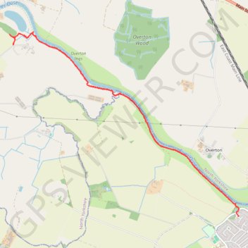
Poppleton to Redhouse Wood by River Ouse
Morning Walk
- Distance: 5.4 mi
- Elevation gain: 115 ft
- Maximum elevation: 49 ft
- Elevation loss: 102 ft
- Minimum elevation: 26 ft
- Moving time: 1 h 57 m
- Moving speed: 2.8 mph
- Maximum speed: 4.2 mph
- Total time: 2 h 4 m
- Global speed: 2.6 mph
Interactive trail map
Thank you for supporting this site ❤️
Make a donation
Make a donation
Gear up for your next adventure:
As an Amazon Associate, this site earns from qualifying purchases at no extra cost to you.
Trail profile
- Distance: 5.4 mi
- Elevation gain: 115 ft
- Maximum elevation: 49 ft
- Elevation loss: 102 ft
- Minimum elevation: 26 ft
- Moving time: 1 h 57 m
- Moving speed: 2.8 mph
- Maximum speed: 4.2 mph
- Total time: 2 h 4 m
- Global speed: 2.6 mph
Thank you for supporting this site ❤️
Make a donation
Make a donation
Gear up for your next adventure:
As an Amazon Associate, this site earns from qualifying purchases at no extra cost to you.
About this trail
Name: Poppleton to Redhouse Wood by River Ouse trail, distance, elevation, map, profile, GPS track
Coordinates: 53.98743 -1.19672 54.00896 -1.15128
Thank you for supporting this site ❤️
Make a donation
Make a donation
Gear up for your next adventure:
As an Amazon Associate, this site earns from qualifying purchases at no extra cost to you.