Thank you for supporting this site ❤️
Make a donation
Make a donation
Gear up for your next adventure:
As an Amazon Associate, this site earns from qualifying purchases at no extra cost to you.
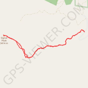
Glenwood Mountain
- Distance: 4.9 mi
- Elevation gain: 1,266 ft
- Maximum elevation: 11,201 ft
- Elevation loss: 1,266 ft
- Minimum elevation: 10,194 ft
- Moving time: 2 h 41 m
- Moving speed: 1.8 mph
- Maximum speed: 4.9 mph
- Total time: 3 h 25 m
- Global speed: 1.4 mph
Interactive trail map
Thank you for supporting this site ❤️
Make a donation
Make a donation
Gear up for your next adventure:
As an Amazon Associate, this site earns from qualifying purchases at no extra cost to you.
Trail profile
- Distance: 4.9 mi
- Elevation gain: 1,266 ft
- Maximum elevation: 11,201 ft
- Elevation loss: 1,266 ft
- Minimum elevation: 10,194 ft
- Moving time: 2 h 41 m
- Moving speed: 1.8 mph
- Maximum speed: 4.9 mph
- Total time: 3 h 25 m
- Global speed: 1.4 mph
Thank you for supporting this site ❤️
Make a donation
Make a donation
Gear up for your next adventure:
As an Amazon Associate, this site earns from qualifying purchases at no extra cost to you.
About this trail
Name: Glenwood Mountain trail, distance, elevation, map, profile, GPS track
Start: Monroe Mountain Road, Sevier County, Utah, United States (38.62623 -111.98462)
End: Monroe Mountain Road, Sevier County, Utah, United States (38.62621 -111.98461)
Coordinates: 38.61843 -112.01571 38.62693 -111.98455
Topography: Sevier County topographic map, elevation, terrain
Thank you for supporting this site ❤️
Make a donation
Make a donation
Gear up for your next adventure:
As an Amazon Associate, this site earns from qualifying purchases at no extra cost to you.