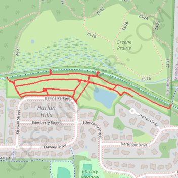
Harlan Hills Prairie paths
- Distance: 1.8 mi
- Elevation gain: 75 ft
- Maximum elevation: 971 ft
- Elevation loss: 72 ft
- Minimum elevation: 938 ft
- Moving time: 29 m 7 s
- Moving speed: 3.7 mph
- Maximum speed: 11.0 mph
- Total time: 30 m 51 s
- Global speed: 3.5 mph
Interactive trail map
Trail profile
- Distance: 1.8 mi
- Elevation gain: 75 ft
- Maximum elevation: 971 ft
- Elevation loss: 72 ft
- Minimum elevation: 938 ft
- Moving time: 29 m 7 s
- Moving speed: 3.7 mph
- Maximum speed: 11.0 mph
- Total time: 30 m 51 s
- Global speed: 3.5 mph
About this trail
Name: Harlan Hills Prairie paths trail, distance, elevation, map, profile, GPS track
Coordinates: 43.02460 -89.44405 43.02613 -89.43526
Topography: Dane County topographic map, elevation, terrain
Other hiking, mountain biking, running and outdoor activity trails
Click on a trail to view its statistics, map and profile.
Paoli via Southwest Bike Path, Badger State Trail and Military Ridge State Trail
United States > Wisconsin > Dane County > Madison
Distance: 26.9 mi • Elevation gain: 945 ft • Maximum elevation: 1,060 ft
Belleville via Southwest Bike Path and Badger State Trail
United States > Wisconsin > Dane County > Madison
Distance: 37.8 mi • Elevation gain: 1,161 ft • Maximum elevation: 1,115 ft